


Mapping the Vote
How GIS Can Help Save Democracy
By Steve Lebofsky
When was the last time that points, lines, and polygons gave you goosebumps? Maybe you struggled to stay awake in high school geometry class, but what if points stood for addresses of unregistered voters? What if lines traced failing infrastructure (like sewer lines)? And what if polygons represented areas in danger of being gerrymandered? That kind of geometry should grab any activist’s attention.
Geographic Information Systems (GIS) blends these vital elements into customized maps and data for varying tasks. GIS is a tool that organizers and grassroots groups can use before and during a campaign cycle. From showing patterns of voter intimidation to educating voters about their elected officials, the possibilities are numerous.

Two different organizations provide technical assistance to grassroots groups eager to apply GIS with their work.
Through the not-for-profit Democracy Labs, Deepak Puri, a Silicon Valley veteran, applies innovative technology to voting rights and social justice causes. Puri and his wife, Shareen Punian, founded Democracy Labs to assist progressive campaigns and organizations at all levels, national, state and local. Democracy Labs specializes in applying free/affordable existing technology and training groups to use it. One example is the SeeSay app which tracks incidents of voter intimidation. You can read about DemLabs’ innovations and applications on the its Substack.
Swing Blue Alliance has developed expertise in applying GIS to strengthen voter outreach efforts. Founded in 2018, Swing Blue Alliance, headquartered in Massachusetts, is the largest all-volunteer, Democratic grassroots organization in the country. Swing Blue Alliance's Voter Registration Data Services team provides targeting strategies and improved voter data to canvassing organizations.

Mapping Unregistered Voters with Swing Blue Alliance
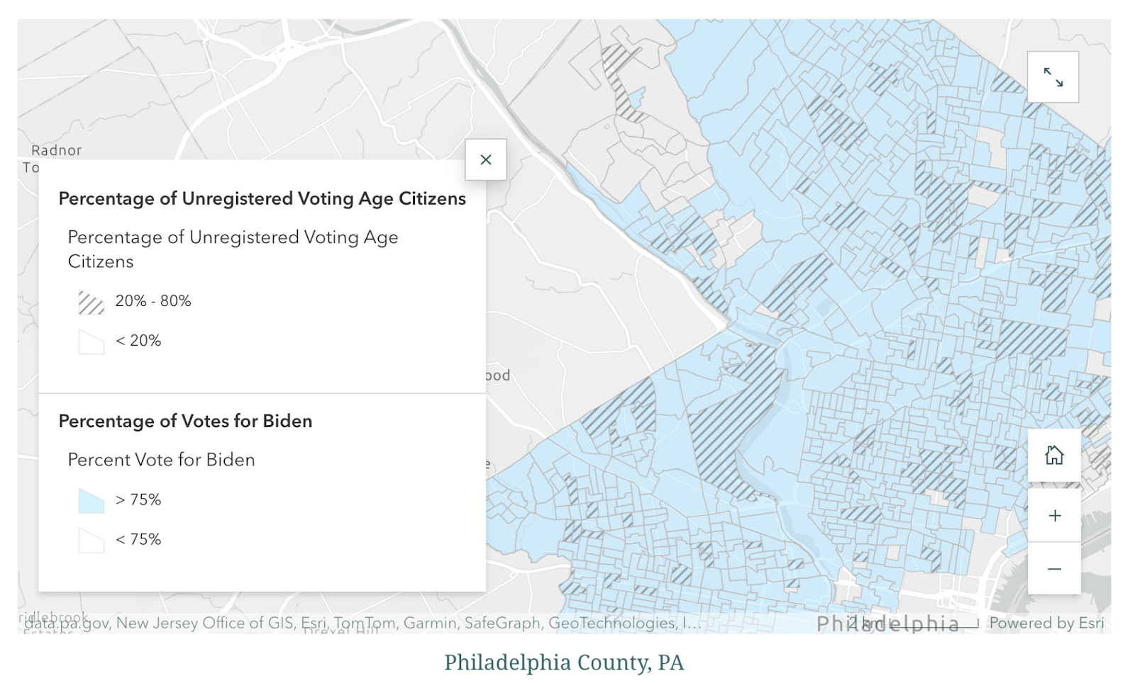
With voter registration in Pennsylvania an urgent need, last spring Sonali Tambe, a member of Swing Blue Alliance’s Voter Registration Data Project, began exploring ways to use GIS to pinpoint concentrations of unregistered Democratic-leaning voters in swing states. Over time, Tambe became an expert at creating interactive story maps for organizations seeking insight into the best areas to target for voter registration.
“Volunteers invest a lot of time and resources when they travel to swing states to knock on doors,” Tambe said. “However, many of the doors they knock on are answered by people who are already registered, are affiliated with a different party, are non-citizens, or may speak a different language. We needed a solution to make the most of the time these volunteers were spending knocking on doors in swing states.”
Using GIS maps based on “precinct-level data,” Tambe has enabled Swing Blue volunteers to quickly see:
Where Democratic votes were cast in 2020;
Democratic leaning areas with higher numbers of unregistered people;
Population density where large numbers can be reached quickly;
Other factors, including language, race, and educational background, which can be added as overlaying maps.
Once Swing Blue shared maps with a few organizations, word spread. Organizers and canvassers don't need to do any geocoding or mapping themselves. Swing Blue assesses each client’s needs and target area, gathers data, and creates the maps. The work flow is pretty straightforward.

Once maps are ready, Swing Blue volunteers help groups identify areas for canvassing and provide them with an updated list of unregistered adults in each of the target areas. Then it’s go-time!
Interested in using GIS for voter outreach? Follow up with Andy Liebman, the contact at Swing Blue Alliance for Swing Blue Alliance’s Voter Registration Data Project. Contact Andy at liebman.andy@gmail.com.
For other questions about GIS, you can contact Deepak Puri at: deepak@thedemlabs.org.
Steve Lebofsky is a retired city planner for the City of Kansas City, Missouri. In his job as a data specialist, he made wide use of GIS.
It's heartening to hear Dems are using GIS, and recognizing the value and support it can provide. Republicans have used it for years specifically to gerrymander.